Wednesday, May 21, 2014

Antikythera Mechanism – An Ancient Computer


Antikythera Mechanism
The Antikythera Mechanism, an ancient analog computer was designed to calculate astronomical positions and was recovered in 1900 – 1901 from the Antikythera wreck, though its significance and complexity were not understood and it is thought to be one of the most complicated antiques in existence.

Towards the twentieth century, diver, Jacques Cousteau visited the wreckage site in 1978, dived off the island of Antikythera and discovered the clocklike mechanism which is presumed to be around 2,000 years old, found in the wreckage of a cargo ship. Though he found the new dating evidence, he did not find any other additional remains of the said mechanism.

The device was very thin which was made of bronze and was mounted in a wooden frame having more than 2,000 characters inscribed all over it. There has not been a publication of the full text of the inscription though almost ninety five percent of the same has been deciphered by experts.

Calculate Movement of Stars and Planets

It is believed to be an mechanical instrument which could have be used to calculate the movements of stars and planets in astronomy and has been estimated to have been built around 87 BC and was lost in 76 BC.

No one seems to be aware of its existence on the ill-fated cargo ship which was a Roman ship while the Antikythera mechanism was developed in Greece. Some were of the opinion that it could have been on the Roman ship since the instrument was among the spoils of war derived by the Roman emperor Julius Caesar at that time.

From the x-ray it was revealed that there are at least 30 various gears present in it. Extensive researches have been done by British historian Derek Price,on the purpose of the antikythera mechanism what it could have been used for. It was only towards 1959 that he put forth his theory that the device had been used in astronomy to make calculations and predictions.

Price presented a model of how the antikythera mechanism could have functioned in 1974 in which past and future dates were entered into the device where it calculated the astronomical information related to the Sun, Moon as well as the other planets.

Some Confirmed Discoveries 

Antikythera Mechanism 1
Some of his discoveries have been confirmed by more recent researches done by various other scholars and scientist though the full extent of the device’s function yet remains a mystery. Price was also of the opinion that the device could have been on public display in a museum or a public hall while others have also come up with their variants of the ancient computer based on the discovered model.

A joint project is also in progress to study further on this amazing device for the advancement of technology of ancient times. Known as the Antikythera Mechanism Research Project, the same is in collaboration between Cardiff University, the National and Kapodistrian University of Athens, the AristotleUniversity of Thessaloniki, the National Archaeological Museum of Athens, X-Tek Systems, UK and Hewlett-Packard, USA.

The project is being funded by the Lever Hulme Trust with the support of the Cultural Foundation of the National Bank of Greece and since the study, great progress has been made with more than eighty fragments of the mechanism that have been discovered.

Wednesday, May 14, 2014

Gateway of Hades

Gateway of Hades – Ancient Legend

Gateway of Hell
Gateway to Hades is an ancient legend which is located in various areas of the Earth openings, gates and doorways according to Daniel Schowalter, professor of religion and classics at Carthage College in Wisconsin.

According to him, he states that even if rituals were carried on at the site associated with the underworld, people probably knew that it was only a cave. Much has been written about some mysterious and menacing dark world of the dead which has brought about a lot of speculation about it and most of the people are unable to comprehend the difference between the terms hell and Hades.

According to him, it is called the realm of Hades, where Hades is considered to be the king. In Roman and Greek conceptions, there is a different conception than what the Christians developed later with regards to hell as a place of final punishment.

Hades - World of the Dead

Hades was considered as the world of the dead and was a place where the dead finally lived which was expected when one died and passed into a different form of life. Schowalter is also the co-director of an excavation site of a Roman temple in northern Israel where he goes on to explain that the early belief of when one died, they would live in the place of the dead which was the underworld.

It was a shadowy place which did not involve punishment and one was not sent there because one had not led a good life but was a place where dead people went.

Famous Twin Caves

Gateway of Hell 2
Researchers who have explored the famous Twins Cave on the outskirts of Jerusalem have discovered evidence of some pagan rituals which dates back to the Roman Empire suggesting that most of the people believed that the cave was some sort of a gateway to the underworld.

The archaeologist of Bar Ilan University found around 42 lamps of clay which dates back to the late Roman era in a 70 foot long vertical shaft in the interior of the cave and is presumed that the lamps could have been used in ancient rituals during the second to the fourth century CE. This could have been to guide the Greek goddess Demeter into Hades in search of her missing daughter.

Site of Pagan Rituals 

Gateway of hell 3
There are various versions to the Gateway of Hell, where some Italian archaeologist claims to have uncovered the gateway to Hades, the underworld from classical Greek mythology in southern western Turkey.

A cave in the ancient Phrygian city of Hierapolis which is presently Pamukkale was considered to be the site of pagan rituals where sacrifice of bulls was done by the priests, to the gods of the underworld, Hades, also known as Pluto to the Romans.

One would find birds lying on the ground which were dead from the poisonous gases the came from the entrance of Pluto’s gate. As reported to Discovery News, by excavation leader Francesco D’Andria, professor of classic archaeology at the University of Salento, he states that people would watch the sacred rites from the steps though they could not get near the entrance of the opening during these rituals where only the priest would stand in front of the opening.

Plutonium/Pluto’s Gate

A temple was also found among the ancient ruins with a pool and steps above the cave which corresponds with the description of the gateways from ancient text. Besides this, they also found columns with inscriptions to Hades and Persephone – Kore to the Romans who was the queen of the underworld.

gate way of hell 4
According to Book VI of the Aeneid, the priestess Sibyl escorted the Trojan hero Aeneas to the underworld. The opening which is known as Plutonium or Pluto’s Gate is known to have lethal vapours with noxious odour and pilgrims it is said would expose birds to the mysterious portal to test the deadly gas emanating from this opening.

The area here is full of vapour and misty that one can hardly see the floor and it is said that if any animal strays in this area is instantly dead, as stated by Strobo, a Greek geographer and historian. The entrance to the grotto of Pluto was covered with the wall of Ionic columns.

Mysterious Noxious Gas – Carbon Dioxide

Gate way of hell 5
Modern belief reveals that the mysterious presence of noxious gas is merely carbon dioxide. During D’Andria’s excavation, he discovered the cave’s lethal properties and believed that the birds died when they tried to get near the warm opening which would kill them instantly by the carbon dioxide fumes.

The Plutonium was destroyed by the Christians during the sixth century and whatever was left of it was completely destroyed by earthquake.

Presently D’Andria together with his team is working on reconstructing this historic site digitally as reported by Discovery News. Historian Alister Filippini states that this seems to be an exceptional discovery since it confirms as well as clarifies the information found from the ancient literary and historic sources.

Tuesday, May 13, 2014

Michigan Triangle – Mysterious Triangle

Michigan Triangle 1
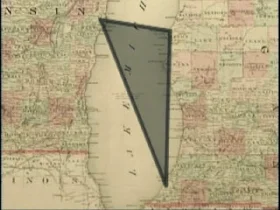
The Michigan Triangle is another geographical triangle besides the Bermuda Triangle which is located in the middle of Lake Michigan and is also a site of various mysterious disappearances of land as well as sea craft which include strange disappearances, ghost ships and even UFO sightings.

The Michigan Triangle has transpired several accounts of activity which are difficult to comprehend by rational thinking. Its first mystery started in 1891, when a schooner, Thomas Hume set off to pick up lumber across the lake and overnight Thomas Hume along with his crew of seven sailors, disappeared without any trace. The wooden boat in which they travelled was never located inspite of extensive search which failed to recover even the slightest details about them.

Michigan Triangle: Rosa Belle Mystery


Michigan Triangle 2
Strange incidents occurred at steady intervals after the turn of the century and another of the mysterious incident was the case of the Rosa Belle. In the year 1921, eleven people in the ship, the members of the Benton Harbour House of David also disappeared and their ship was found floating in the Lake Michigan which was overturned.

Though it seemed to be damaged in collusion, there were no reports of any other ship engaged in accident or any remains which could have been found. Several people found this mysterious because the Rosa Belle had been rebuilt after the wreck of the 1921 incident.

Legends with regards to these incidents mounted with reports about the triangle claiming that a number of weird occurrences took place during the passage through this area. Some claimed that this triangle seemed to be a time portal which either slowed or quicken the time immensely during the passage while others considered that the UFO’s were spotted in the area or reported bright lights in the sky.

Legend – A Powerful Entity


Michigan Triangle 3
Greg Newkirk
Chilling accounts supported the legend over a period of time and soon many were relating about strange weather phenomena or feeling of uneasiness while navigating in the swath of the lake. Though several experiences taken place varied, the legend has grown to be one of the powerful entities to keep many away from this triangle.

A historian, Bill Wangemann from Sheboygan, Wisconsin had spent several years gathering tales about the Lake Michigan triangle. Another author Linda S. Godfrey has mentioned in her book, Weird Michigan, thatthe Triangle begins from the town of Ludington to Benton Harbour in Michigan, while another links from Benton Harbour to Manitowoc, Wisconsin and the final side connects Manitowoc back to Ludington.

Michigan Triangle  Mystery


The legend does not end with ships that have been sunk but there are also incidents of disappearance of around forty planes over Lake Michigan, the most famous being the northwest airline flight 2501 which took off from New York City heading for Minneapolis in June 1950 which plunged in Lake Michigan just off Benton Harbour with no survivors.

Inspite of it all, there are many who have made their journey through the Triangle like Captain Kevin Fitch of the Badger Ferry who has been sailing the Lake Michigan water for about thirty years. According to him, the thousand trips conducted by him across the lake, has not given him any incidents of anything strange which is not fitted with an explanation and he continues to ferry across the waters of Lake Michigan which is considered to be very dangerous by many.

Sunday, May 11, 2014

Mellified Man – Legendary Medicinal Substance

Mellified Man 1
Mellified Man or human mummy confection relates to a legendary medicinal substance created by steeping a human cadaver in honey and the concoction is mentioned in Chinese source only. Presumed to be from Arabia, mellified man was mentioned in the 16th century by Chinese pharmacologist Li Shizhen in his Bencao Gangmu where he mentions in the final section under the entry for `munaiyi’.

 He reports that some elderly men in their 70 and 80 years of age in Arabia, who were nearing their end,would be willing to give their bodies to save others and would submit themselves for the process of mummification in honey to create some sort of healing confection. Chinese as well as European pharmacopeias’ employed medicines of human origin.

Process of Mellfied Man


The process would differ from a simple donation of the body due to the aspect of self-sacrifice where the mellification process would start before their death. In this case the donor would stop consuming any food besides honey and would also bathe in honey and according to legend, his sweat, faeces etc.; would be of honey and when the diet would prove to be fatal, the body would be placed in a coffin made of stone and filled with honey.

Mellified Man 2
The date is mentioned on the coffin indicating the year and the month and after a century or so, the coffin would be reopened and the contents would then be turned into a kind of confection which would be capable of healing broken limbs and various other ailments. This confection would be sold in the street market as a most precious item which would be difficult to obtain and at a very high price.

Importance of Honey in Mellified Man


Honey is a substance which is often used in funerary practices in various cultures. The Burmese priests follow the custom of preserving their chief abbots in coffin which are full of honey and its reputation for medicinal use as well as durability is well established.

 For over 2,700 years now, honey has been used by people in treating various ailments through topical application, and recently it has the antiseptic and antibacterial properties of honey being chemically explained.

Mellified Man 3
Due to its unique capabilities and the complex process of nectar by the bees that changes its chemical properties, honey has been considered as a long term storage which is easily assimilated even after preserving the same for a very long time.

Antibacterial properties of honey are also the outcome of the low water activity causing osmosis, hydrogen peroxide effect with high acidity, the combination of high acidity, hygroscopic and antibacterial effect which has resulted to honey’s reputation being an appropriate choice to mummify a human cadaver.

Mummies were very common in the Middle Ages till the eighteenth century and it was not only useful as medicine but also as fertilizers as well as useful as paint. The use of the corpses and various parts of the body which was used as medicine dates back to the Roman Empire, where the blood of the dead gladiators was used in the treatment of epilepsy.

Saturday, May 10, 2014

Atacama Alien

Atacama Alien - Tiny Alien Close to Human than Chimpanzee

Atacama Alien 1
The tiny `alien’, humanoid of a creature found in Chile’s Atacama Desert which looks like a shrunken version of a monster has been confirmed as a human after extensive testing by the Stanford University scientists. It is close to human than chimpanzees and is believed to have lived to the age of six to eight according to Garry Nolan, director of stem cell biology at Sanford University’s School of Medicine in California as per the Daily Mail.

Atacama Alien 2
It could have been breathing, eating or metabolizing and the question is how big it would have been when it was born. This six inch skeleton, which has been nicknamed `Ata’, and found in Atacama Desert in 2003, has been a source of great speculation since then and while some have claimed that the odd skeleton could be that of a primate or aborted foetus, conspiracy theorists focus on to its elongated skull as evidence that it is an alien which could have crash landed on the planet.

Researchers though have conducted DNA test which indicated that the skeleton had earthly origin and testers believe that the tiny creature could have be around six to eight years old before its demise as reported by Discovery News.

Atacama Humanoid/Ata

Atacama Alien 3
This was discovered over ten years ago by a local in the Atacama Desert, who had been looking for objects of historical value in the Chilean ghost town of La Noria. The six inch long Atacama Humanoid, has hard teeth, dark, scaly skin with bulging head that had a lump on the top and nine ribs.

Its huge head and rib count has been associated with extra-terrestrial beings leading many to hypothesize that this alien had more in relation to E.T. than humans. Nolan states that it is an interesting medical mystery of an unfortunate human with series of birth defects where currently the genetics of which are not very clear.

Atacama Alien 4
There seems to be a lot of discrepancy regarding the Atacama alien. According to Paola Viscardi, a natural history curator at the Horiman Museum in London, it seems impossible that this skeleton could have come from a child between the age of six and eight.

Atacama Specimen – Mummified 

He had found it amazing since he had dealt with skeleton foetus specimens which were similar to this in museum collection, as mentioned in his blog, Zygoma. He further states that the Ata specimen could probably be an aborted foetus of 14 to 16 weeks which could have been ceremoniously neglected in the desert where it went through a natural mummification process.

Atacama Alien 5
According to him, the difference he had concluded on discerning the high quality photos, x-ray and CT scan was that the Atacama specimen came from a slightly earlier stage foetus, mummified soft tissue which had shrunk tight pulling the rib cage into a more narrow configuration while the head had been distorted as a result of an illegal abortion where a hook could have been used to extract the foetus thereby causing damage to the back of the skull and stretching the pliable head.

He also admits that the hole could probably have occurred during the examination by the scientist that could have been consistent with other images which shows a skull without a hole

Friday, May 9, 2014

Carnac – Home for Carnac Stones

Carnac Stones
Carnac, a small village of around 5,000 people is in the region of Brittany, north-western France and is a home to the Carnac Stones, a system of over 3,000 prehistoric standing stones. Carnac is known for its unique rows of ancient standing stones all over the world with many tourists coming to this destination to take a look at this amazing structure.

The Carnac stones are exceptional, the largest collection of megalithic standing stones in the world occurring in a number of Neolithic sites around the French village of Carnac in Brittany, which include rows of stones consisting of alignments, multi-stone clusters - dolmens, tumuli and single standing stones - menhirs. The stones were erected somewhere during the Neolithic period around 3300 BC though some could be as old as 4500 BC.

Over 3,000 prehistoric standing stones were cut from local rock and were erected by the pre-Celtic people of Brittany which seems to be the largest collection in the world. A majority of the stones are within the Breton village of Carnac though some to the east are within La Trinite-sur-Mer.

Groups of Stones - Menec/Kermario/Kerlescan

Carnac Stones 1
In recent centuries most of this site wore prone to negligence with reports that the dolmens were being used as sheep shelters, chicken sheds or even used as ovens while the stones have been moved to make way for roads or could have been used for building purposes.Although the Carnac stones dates back from 4500 BC, modern myths developed resulting from 1st century AD Roman with Christian occupations later, like Saint Cornelius, a Christian myth which were associated with the stones held that they were pagan soldiers in search of Pope Cornelius when he had turned them to stone.

Local tradition claims that they stand in such perfect straight line is because they are a Roman legion who have been turned to stone by Merlin. There are three types of groups of stone rows namely Menec, Kermario and Kerlescan which could have formed a single group once but may have split up, as stones were moved for other purposes.

Erected by the Megaliths

Carnac Stones 2
Though the Carnac stones were cut from local rock and erected by the megaliths, the precise date of the stones is difficult to ascertain since little records and material has been found beneath them, though one interpretation of the site is that successive generation could have visited the site in order to erect the stones in honour of their ancestors.

The Menec alignment are twelve converging rows of standing stones stretching over a kilometre and the remains of a stone circle at either end. The largest stones which are around 4m thick are at the wider western end which gets smaller along the length of the alignment arriving at around 0.6m high at the extreme east and growing in height.

Towards the east further on, the fanning layout is repeated in what is known as the Kermario alignment. The standing stone of Carnac are one of the greatest attractions of Brittany. The granite stones which were erected on the spot were from where they were dug and hence the difference in their sizes, though it is unknown why they were put up there. Some presume that they could have been erected due to religious or cultural significance.

Wednesday, May 7, 2014

Mysterious Non-Existence Of Island Sandy

Island Sandy
The History Mystery of Sandy Island, a non-existent island had featured on the world’s map for over a decade as being located near the French territory of New Caledonia between the Chesterfield Island and Nereus Reef in the eastern Coral Sea. The island was included on many maps as well as nautical charts in the late 19th century which gained great media and public attention in November 2012 when R/V Southern Surveyor which was an Australian surveyor ship that had passed through the South Pacific when the crew noticed an interesting discrepancy between their navigational maps and other atlases that were abroad.

 Every source that was checked showed a small speck known as Sandy Island located halfway between Australia and New Caledonia. The surveyor that had arrived at the site of Sandy Island in the middle of the night had left some of the crew and the captain worried that they might run around on land just beneath the surface though their depth sounding equipment showed ocean floor that was thousands of feet below indicating that the island did not face any recent volcanic scene or never existed at all.

No Trace of Sandy Island

Island Sandy 1
A team of explorers who had been traveling to a remote island off the coast of Australia made an unusual discovery. There was no trace of the tiny island known as Sandy Island which appears on all maps and atlas in the world.

The Island was then quickly removed from several maps and data sets inclusive of the National Geographic society and Google Maps.When viewed from Google Earth, Sandy Island appeared like dark, silver tantalising amid the shimmering vastness of the Pacific Ocean but when marine scientist arrived at that island in the Coral Sea off Australia they were surprised for something that did not exist. There was just the blue Ocean instead of sandy outcrop with palm trees that were supposed to be there,

An Enigmatic Island

Island Sandy 2
Maria Seaton, the Australian scientist, a geologist at Sydney University had started a voyage to study plate tectonic and had spotted the enigmatic island which lay along the route.

Though the island appeared on the Google Earth map, there were several discrepancies and no images of it. Moreover it had also featured on the reliable world coastline database for the past twelve years but there seems to be no sign of it on their sea chart.

This has led to a lot of speculation as to why do every map and atlas indicates a place known as Sandy Island. Some sources indicate that Sandy Island was approximately 60 sq. miles in size somewhat the same area as Manhattan meaning that it would have been an insignificant piece of land but the mystery lies in how did it manage to get on the maps and atlas.

According to a theory, the island seemed to have been placed by a cartographer on purpose who tried to prevent the copying of his maps. In the past it was not unusual for mapmakers to deliberately put mark on their works in order that they could identify copies made by others and there could be a possibility that Sandy Island could have been just another mark.

Sunday, May 4, 2014

History Mystery: Nan Madol – A Ruined City

Nan Madol
Photo credit: Jeff
Nan Madol is a ruined city which lies off the eastern shore of the island of Pohnpei and is presently one of the four states in the Federated States of Micronesia that used to be the capital of the Saudeleur dynasty till 1500 AD.

The city constructed in a lagoon comprises of small artificial islands which are joined together by a network of canals and often called the Venice of the Pacific and the name Nan Madol which means `spaces between’, is referred to the canals which criss-cross the ruins.

A local story relates that when Nan Madol was being built, a powerful magician who lived in the well had inhabited the region on the northwest of the island and had helped in completing the building and was in fact responsible in supplying the huge stone logs used in Nan Madol which was done by flying them from their source to the construction site.

Though this tale is treated as a legend rather than history by some archaeologist, the story accounts for the fact that the major population centre seemed to be on the opposite side of the island from Nan Madol besides which the type of stones used in the construction was not found nearby.

Ceremonial and Political Seat of Saudeleur Dynasty

Nan Madol  1
Credit: David
It was the ceremonial as well as the political seat of the Saudeleur dynasty uniting Pohnpei’s estimated population of 25,000 inhabitants till 1628. Placed between the main island of Pohnpei and Temwen Islands, it is a part of human activity from the early as the first or second century CE.Towards the 8th or 9th century, islet had begun though the distinctive megalithic architecture had not begun till the 12th or early 13th century.

According to Phnpeian legend, Nan Madol seemed to be constructed by twin sorcerers, Olishipa and Olosohpa from the mythical Western Katau or Kanamwayso. The two brothers had arrived in a huge canoe in search of a place to buildalter where they could worship Nahnisohn Sahpw who was the god of agriculture where they managed to build one, off the Temwem Island and performed their rituals there.

An Archaeological District

Nan Madol 2
Presently Nan Madol is an archaeological district covering over 18 km including the stone architecture built up on a coral reef along the Shore of Temwen Island with several other artificial islets together with the adjacent Phnpei main island coastline.

The site with its stone walls covers an area of around 1.5 km long by 0.5 km wide containing almost 100 artificial islets, stone and coral filled platforms which are bordered by tidal canals. Carbon dating shows that the Nan Madol construction began around 1200 CE and the excavation indicates that the area could have been occupied early in 200 BC.

Some quarry sites around the island have been identified though the exact origin of the stones of Nan Madol is not known. In the year 1985, the ruins of Nan Madol were declared a National Historical Landmark and presently great effort are being carried out in order to preserve them.